French River Canoe Trip Report May 20-23, 2016
Mercer Lake – Hall River – French River Main Channel – Hwy 69
Total Distance 70 km

French River Route 2016
Participants*: God of Fire, Hemingway, Johann, Mad General, Garry, Master of Blades
*The pictures and monikers below may even bear a resemblance to people you know – your eyes deceive you. These are not the people you know.
We’d like to thank and recommend the BeauseJour Resort Restaurant and Inn for being an excellent place to stay the night before embarking on a *rigorous* French River canoe and camping trip. Also, our outfitter Claude at the French River Supply Post took good care of us – they are very conveniently located on the water at our take out, and short 45 min ride from our put in.
Day 1: Mercer Lake to Free Flowing Channel – 13 km
After a 40 minute shuttle from the outfitters up highway 69, across highway 64 through Monetville and down the Dokis Reserve Road, we put in at a public access point at western edge of Mercer Lake. Claude, our driver and owner of the outfitting store, told us this was public land often used by locals as a free camping site for trailers with no oversight, so “if we heard banjos, start running.” Taking Claude’s advice we loaded our boats quickly and set out under a perfect 20 degree blue sky.
Mercer Lake is framed by beautiful rock outcroppings of the Canadian Shield. The land lends itself to multiple camping sites, with almost every small peninsula offering exposed rock for fire pits and moss flats and pine needle beds for shade and tents. After about 5 km the Lake begins to narrow and the current picks up signalling the transition into Hall River. We followed the lake to its conclusion, which was a small ribbon of white water wedged between the knuckles of the Shield. Our water was high, so 2 boats chose to line the short rapid (30 meters, maybe), while on river left before entering the chute a series of rollers have been established for those who wish to lift / carry / roll their boats into the small inlet river left. In higher water this may be a fun little set with a bit of a drop at the end. In low water it would be a bump and grind scrape job on the boats.
This marked the start of Hall River which was an easy enough paddle down to our destination. The river was moving well and widens slowly over 3 km. It is important to stay river left once the Hall opens up in order to avoid a small, but nonetheless inconvenient dead end bay that invites you in on river right.
Past this point a small hydroelectric dam marks the first drop down point to the section of the river that leads through the Dokis Reserve and on to the Five Finger Rapids. Do not take this route. Not only is it a portage, but this exit will land you on the wrong side of the island that has created this geography and you will be forced to paddle at least 10 km out of your way through the westward pushing river before doubling back to the Dokis channel. Just beyond the dam the entrance to the Free Flowing Channel is marked by a magnificent campsite of bleached Canadian Shield ascending in smooth terraces river right just at the entrance to the drop down channel. There are multiple options for fire pits (we chose the exposed peninsula near the water’s edge due to low wind and brilliant weather), but other areas on this large site offer differing degrees of shade, elevation, etc. There are equally many excellent tenting spots.

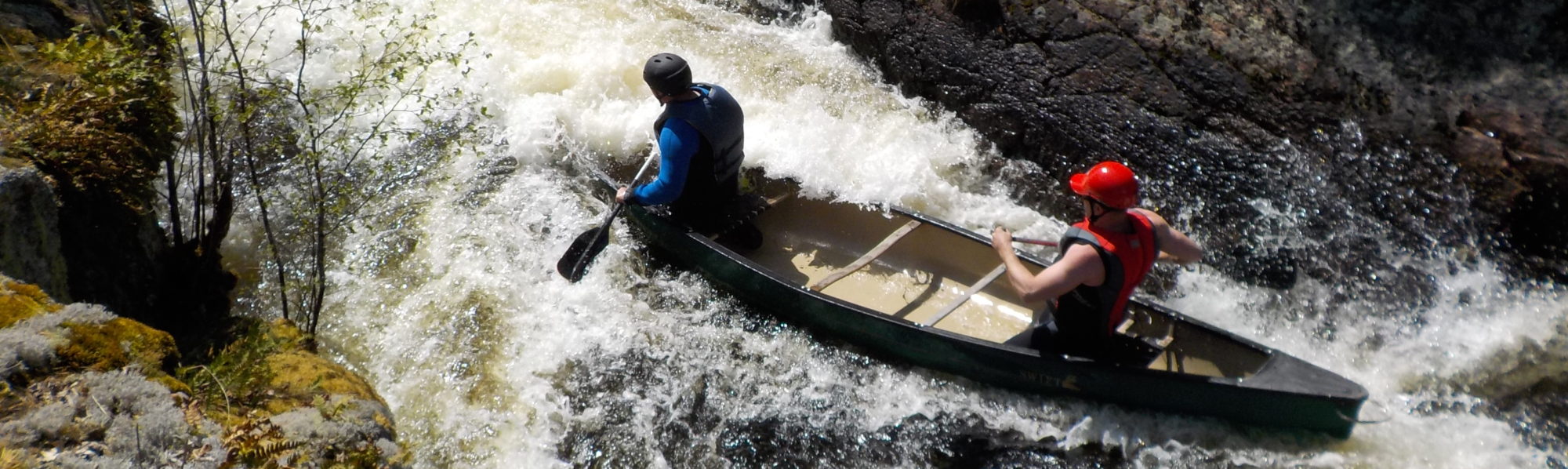
We unpacked, made camp, took a short rest before putting on our wetsuits to prepare for some practice sessions on the small set of white water 200 meters south of our campsite. The drop down channel opens up slightly before narrowing against a sheer rock wall river right. On river left visible signs of an unofficial portage trail can be seen. We parked our canoes there to scout.

Free Flowing Channel – Camp Site
This set in high water is fairly straightforward. The main tongue drives centre left into a series of large standing waves. Centre right leads into a series of strong curling waves that can either flip you or drive you into the rock wall.


Mad General and Garry learned this the hard way on their second run and T-boned the wall before dumping.
Hemingway and Master of Blades were slow on their C curve while eddying out and also got flipped. In high Spring water the two greatest threats are swamping and the risk of hypothermia, but beyond that everyone, when sticking to a simple line, was able to shoot the set tandem or solo multiple times event free.
Successful runs:
Solo:
Shenanigans:
After an hour we paddled back upstream to our camp to prepare for an unbelievable display of meats and cheese courtesy of the Maslo Family’s Meat Factory and watched the fire dance with the appropriate amount of beverages in hand.
Day 2: Free Flowing Channel – Dokis Bridge – 5 Finger Rapids – 17 km
Broke camp to another beautifully clear blue sky and decided to portage around the Free Flowing Channel instead of running the rapid full boat. The size of the standing waves and the amount of water we took on practicing the day before, plus the frigidity of the water, led us to conclude that keeping the day moving was better than putting on wetsuits and risking swamping.
After the rapid stick to the left shore as the river expands into a small bay then narrows before splitting around a large island. The right channel will briefly take you south west before wrapping around to join the eastern course, and while not a major setback, it is best avoided. At this point the river really picked up creating small swifts in the narrows. Due to the volume of water large boils would randomly form throughout the paddle and due to their strength and suddenness that have the potential to throw off the canoe balance, they need to be noted and respected. We passed under the Dokis reserve road bridge rather quickly and soon hit the sharp turn in the river and began paddling due west. This section is much more open and event free. The only caution is that after about 3 km the river opens on the right into Bear Bay and while this is not a major obstacle, it’s deep enough to make the misfire tiresome. Just past Bear Bay the river narrows again signalling the final switch back to the 5 Fingers approach approximately 1.5 km due east. The mouth of the nearest branch of the rapids is located in the second small bay river right. We could hear the rapids before we saw it and it is best to advance with caution. In high water this is an R5 and the size of the hole at the bottom of the first leg of the set is lethal. The official portage is river right and clearly marked with multiple strong campsites.


Watch it move:
Hemingway, Johann, Mad General and Garry decided to explore the less obvious and worn portage trail river left while God of Fire and Master of Blades paddled further east to explore the other entrance to the rapids. Both channels converge around a large island and meet to form a single flow that passes through one more set before dropping you into the French River proper.
God of Fire and Master of Blades returned to report that the farthest channel consisted of three rapids ranging from R2-R4. The first two could be run cautiously with empty boats due to the size of the water and various ledges, but that the last set ended with a small waterfall drop of over 8 feet making it impossible to pass. Portage trails were also not clearly marked, so anyone at this time of year interested in running these rapids would face a lot of bush whacking in order to make it through.
We opted to portage our gear onto the elevated peninsula that sat above the convergence point of the two river bands and while the bugs were bad, the campsite offered a perch from which to catch a breeze and watch the river below, while also isolating us from the numerous visitors who had come to the 5 Fingers to relax for the day on the south and west shores.


Mad General and I toyed with the idea of going up with an empty boat once we were unpacked to the section that God of Fire and Master of Blades had scouted, but due to fatigue opted out. We both agreed after the fact that perhaps we should have given it a go. From what we saw there were a lot of fun sections on the river and with the proper patience and scouting, avoiding the major pitfalls would have been more than manageable. I am curious to know what that part of the world looks like in lower water. Next time.
Up close and personal:


A small amount of welcome rain came in just at sunset and lasted no more than 1 hour. Given the engineering background of the group a small tarp was set up for shelter, and after eating some more sausage and a lot of random snacks, some of which can’t even be remembered, most people began passing out.
Boom!

Amazing campsite, careful where and how far you wander when nature calls:


Day 3: French Main Channel – Little Pine Rapids – Big Pine Rapids – Double Rapids – The Ladder – Little Parisien Rapids – Big Parisen Rapids – Crooked Rapids – 5 Mile Rapids – Parisien Island – 20 km
We did our best to break camp in decent time. God of Fire had the hemp heart granola & coffee and Baileys ready to go in no time, and despite being hung over Johann and Mad General managed to get themselves together after a good visit to the throne and a solid sweat.
The bottom section of the 5 Fingers was still treacherous due to the high water. We front ferried across the outwash of the converging rapids and made for the south shore to scout the final set. The water continued to move at a deceptively powerful pace so our original plan of lining the final set with full boats was quickly abandoned after we realized just how strong and deep the current was. We got as close as possible to the main tongue before portaging about 25 meters over a series of boulders.
This final set of the 5 Fingers is very runnable and in low water it would be a lot of fun. Mad General was really keen to give it a go, but Garry wasn’t interested in getting hypothermia first thing in the morning. They went back and forth on this for a while, which eventually gave rise to Mad General’s new name, the Mad General. Garry may have hoped this would dissuade Mad General from further lunacy, but it only encouraged him. He even considered soloing the set. Please note, Mad General has never soloed in his life. We should have let him try.
Once you exit the 5 Fingers it becomes abundantly clear that you are now in the land of the living. The relative isolation of the previous section of the trip is immediately interrupted by fishing boats, leisure boats, cottages and outboard motors. While the area we were in was technically the French River, it feels more like a lake due to the width and multiple islands of this section. The crossing from the 5 Fingers to the mouth of the Main Channel is a 4 km zigzag through multiple islands that prevent a straight line paddle. In the end the mouth of the Main Channel is fairly obvious once you are close (aim for the highly visible Lockhaven Wilderness Lodge and keep it on your left as you enter the bay), but in order to avoid taking the long route around islands or circulating dead end bays, have your map handy and check your landmarks regularly.
Little Pine Rapids marks the start of a 7-8 km section of white water on the river. We stopped to scout the rapid just to get a sense of the size and speed of the water, and found that the volume had actually turned Little Pine into one long arching R1 that was run easily following the main tongue river left. The river was moving and as mentioned before on Dokis, it was actually the eddy lines and the boils that were the most challenging part of the set. Once clear of Little Pine we flew down to Big Pine which had also been turned into a straightforward R1 as well. As much as it is important to follow the map for the rapids, it’s also important to be aware of wrong turns on this section of river. Just past Big Pine the channel opens up. The continuation of the river is on your left and is a hard turn south through Double Rapids and The Ladder. If you miss this opening you will end up paddling 4-5 km into a dead end bay. In high water Double Rapids and The Ladder were washed out, so using white water as a landmark can be deceptive this time of year. Look for the southern opening on the south shore and take it. Even though it was washed out a faint tongue was still visible that marked where the Double should be.
After the wash out we arrived at Little Parisien which was a beast. This R3 sits between two frames of exposed, rolling shield so it can be scouted on either side and there are multiple options for running it depending on whether you want to go open or full boat. We were pressed for time so we opted for a full boat run. We all chose the same line, starting centre right through the main standing waves and drop at the start, back paddling through the centre chop in order to line up a hard eddy out just below the last drop avoiding the 5-6 major standing waves and strong current that will swamp you and sweep you down the river at the end. The power of this section of the river is such that the eddy pool created from the bottom of the rapid is so powerful that all three boats almost swamped eddying out due to the force of change of direction and size of the water. Hemingway and Johann went first, followed by Master of Blades and God of Fire, followed by Garry and Mad General. All three runs were solid with each group facing the greatest challenge in the final section, as outlined above, although Mad General and Garry’s was arguably the cleanest exit. They were able to eddy out before hitting the monster waves at the bottom of the set which made them less heavy with water when breaking the eddy line. This was a monumental run for Master of Blades who had just learned how to shoot white water on our first day, so despite his nerves and with the excellent coaching of God of Fire, he successfully tackled his first R3. We celebrated by deciding not to have a drink.
Graceful elegance:


We pushed on down the river through the Big Parisien Rapids which had been turned into a swift. It is important to stay river left when approaching Crooked Rapids since the right side of the river opens up into Wolfe Cove which is a 8 km dead end that will really make your day painful if you take a wrong turn. Crooked Rapids was an easily navigable R1 as long you followed the natural flow of the current moving river left. Once you pass through Crooked Rapids, move river right as one last very long labyrinthine arm of the river drops south west and will lead you astray.
From this point on the rapids section of the trip was over. The French moves west towards civilization like some great lumbering Leviathan so we decided to stop and fuel up before the final push. We passed Cross Island and completed the final 6 km to Parisien Island where God of Fire found a beautifully exposed peninsula of rock on the north shore to set up camp and pray to the fire gods. After three glorious days under an unrelenting sun we were pretty beat up, but Master of Blades went to work on his home made chilli and butter bannock, further cementing his candidacy for Rookie of the Year, God of Fire threw on his wetsuit and floated in the calm waters a la the funeral scene for Clean in “Apocalypse Now”, and Johann disappeared up river in a solo canoe to look at rocks. Just after dinner 5 jet skis ripped across the river full tilt in an awesome display of skill and adrenaline. Mad General almost defected on site, but Garry managed to remind the Mad General that we still needed him for one more day.


We tried our best to spend our last night on the river in revelry, but by 10:30 most people were in their tents. Some minor excitement in the night had a few people thinking bears were on patrol, but the chainsaw snoring of Master of Blades, Johann and Hemingway provided a noise perimeter that kept the wildlife at bay.
Day 4: Parisien Island – Hydro Wires – Outfitters – 20 km
We broke camp in decent time and paddled due west into the widening waters. The first 10 km is a straight shot west with very little deviation and no dead end inlets. Although the weather was good, a head wind began to pick up and the size of the river, coupled with the wind, makes you feel as though you are on a massive lake as opposed to a flowing river. We hugged the shorelines in order to manage the head winds and as long as you aim for the hydro wires in the distance and pass under them there is no reason to lose your way. But that, of course, didn’t stop us from doing just that.


Just before the hydro lines there are a series of islands that appear to provide a narrower series of channels leading around a large section of the French that looks like a massive bay. For some hazy reason we decided to take this route in the hopes of finding some fast moving water, but instead had to battle even stronger head winds and choppy water. The distance over the islands versus under the islands is the same, so we lost no distance, but this was not the short cut we intended, and on a normal day we might not have been so confused, but it was Monday, and were in the back 1/3 of our day, and we were notorious for not being a sharp as we could on the back 1/3.
Once through this section we came to Lost Child Bend. Across from the bend is Four Mile Island. We opted to take the north arm around Four Mile Island and because we didn’t have any maps beyond this point, there came a brief moment of being unsure whether we were totally lost and had crawled up some dead end inlet. Fortunately Mad General summoned the power of the Gipper and we managed to calibrate ourselves. In the future, the south arm around the island might be an easier route out. When you get to Lost Child Bend, drop south into that channel and the rest becomes academic.
Thanks to Mad General, we passed through one last narrow channel of shield before reconnecting with the Main Channel. Johann tried talking to some locals which almost got us killed. We headed south down the river towards the Golf & Country Club on the south shore and found the opening on the right to where the river narrows again on its final journey to Georgian Bay.
One last 1km push up the river and under an old CPR bridge and the Outfitters came into sight.
Cue the banjo.
Until next year!!!
Thank you so much for your field notes. Looks like you guys had a fine trip.
I am plotting a trip on the upper French, and your detailed notes about the portage locations for the Five Finger and Free Flow channel are invaluable to me. Nowhere else was I able to find the specificity of these details in terms of river left or right. (books, maps, MYCCR etc : nothing). Much appreciated for the clarity your provided.
Hi Colette, glad to hear you found the report useful!
Hi there. Many thanks 🙂 Interesting page :).
Glad you liked it!
Thank you for sharing your trip in detail.
I own the last piece of property on a Mercer Lake road before you get to the landing on Mercer Lake
I’ve always wanted to to try canoeing that stretch but stop at Wolseley Bay instead of going out to sixty nine which shortly will be the 400.
I have a rental loft and thought of starting a little outfitting business just to get people in a canoe and try that trip.
Thanks again
Jay Colenutt
Hi Jay. Glad you enjoyed the write up. We’ll keep you in mind if/when we find ourselves planning another run at the French.