Madawaska River Canoe Trip Report:
Upper Madawaska River – Bark Lake – Middle Madawaska – approximately 62 km
July 16, 2015 – July 19, 2015

Madawaska-River-Canoe-Trip-Report-Route-2015
Participants: The Mad General, Johann, Happy, Andre, Prometheus, Ahnold
Day 1: July 16, 2015: Town of Whitney – Rapid Lake Chutes – Rapid Lake 1.5 km
So begins the official chronicle, our Madawaska River Canoe Trip Report of 2015. We converged in the village of Whitney a few hours before sunset under damp skies and low water conditions. There are two bridges that span the Upper Madawaska. The western most bridge carries the direct traffic in and out of Algonquin’s East Gate, just 5 km up the road on the 60, so we decided to put in below second half of Village Rapids, which was easily accessible through a visible side road that parallels the river on the northern shore. There are multiple access points off the road that reach the river. In low water the heavy brush of the bank gives way to exposed rock and makes for easy access. In high water I imagine it is a different affair.
The heavy skies gave us a false sense of time and despite moving quickly we found ourselves setting off under a rapidly descending darkness. We pushed down river to the Rapid Lake Chutes hoping to shake off our car legs with some white water, but were met with a firm confirmation of the low water levels that had been hinted at up in the Village. In high water the Chutes are categorized as R3-R4s, but for us they became a series of rough channels of water pouring over rock ledges and boulder gardens. A combination of drags and lifts were engineered in order to pass through and if we had not been racing against the dark, there may have been opportunities to run certain sections of the rapids since it is divided into two different chutes with an island in the middle. However, the rain picked up, the bugs came out, so we were forced to push through and found a campsite on a small outcropping of flat rock in the small bay just above Rapid Lake on river left.
The Mad General raised our blood sugar with magnificent meats, Andre lifted our spirits using the last of his iPhone’s juice to play “Strangers” by The Kinks, and Prometheus lifted our core temperatures by getting a fire going before the rain really set in, but the bugs were bad, the quarters cramped, and the rain unrelenting so it wasn’t long before it was all she wrote.
Tough First Night…

Madawaska River White Water Canoe Trip – Day 1 – Broken Thwart

Day 2: Rapid Lake: Bunch of Named Rapids that ended up being swifts – Hermann’s Chute – more bump and grind – Devil’s Elbow – 14.5 km
*It is important to note that the Upper Madawaska has a rich white water tradition. After Rapid Lake there are 8 identified sets before Devil’s Elbow. They are in order: Approach Rapids, Long Rapid, Rustle Rapids, Hermann’s Chute, Tight Turn Rapid, The Uncountables, Devil’s Approach. In mid to high water these rapids range from R1s to R4s. However, due to the low water, the vast majority of these rapids were reduced to Swifts or very easily negotiable R1s that simply required finding the central tongue of the water and following it down the middle. Anyone shooting this stretch of the Upper Madawaska in conditions other than ours should consult a secondary trip report.
We woke up to clear skies and a warm sun that had all but dried out our gear from last night’s rain. Prometheus did what Prometheus does and built a glorious fire for our bacon, eggs and coffee while everyone got themselves sorted out for the upcoming day. We broke camp leisurely and passing under an old iron rail bridge atop which sat two young fishermen, casually entered the 2km stretch of Rapid Lake proper. Rapid Lake itself was an easy paddle. The narrow features of the lake prevented any real wind from impacting our progress and as we approached the mouth of the Approach Rapids the low water allowed for the smooth burnt orange rock of this section of Ontario to rise up and frame our journey.


As stated above, our descent through Approach Rapids, Long Rapids and Rustle Rapids can be read as one continuous narrative. The next 4.5 km were such that the river, while still fast moving and beautiful, became a shallow channel through rock gardens requiring each canoe to target the central tongue of each set and continually locate the deepest water. There was just enough water and just enough technical maneuvering on each set that we needed to be prepared to quickly jump out and drag our boats should they get hung up on a rock. On more than one occasion the Mad General and Andre almost tipped due to a sudden loss of balance brought on by beaching themselves on a shallow ledge.
As we approached Hermann’s Chute the strength of the land became more and more apparent as we carved our way through the rising sun blanched rocks. Shortly after Rustle Rapids, be prepared to eddy out river right just above Hermann’s Chute, even in low water. The portage trail is clearly marked and the roar of the falls, even in low water, can be heard upstream. The Chute itself is magnificent. The uppermost portion provided multiple rock ledges and powerful spouts that converged into one single channel that punched through a canyon of 25 foot high rocks perched as gatekeepers to this section of the river. We decided to take lunch at the bottom of the Chute and run what sections we could in empty boats. The Mad General and Ahnold lined their boat just below the first exposed ledge and ran the bottom 2/3 of the rapids in a straight line down through the central tongue of standing waves and through the canyon chute easily. Prometheus soloed the same line without incident. In between feasting on Happy and Johann’s beef jerky and cheese, plus the occasional piece of fruit, several of us took advantage of the Chute’s canyon ledges and did some cliff jumping – much fun.
The Wide Angle:

The Run:
The Cliff Jumping:
The next 5 km played out very similarly to the start of the day. The Untouchables Rapids, Amable Rapid and the Devil’s Approach wend their way through the gentle Upper Madawaska Valley providing a familiar mixture of fast moving central channels, rock gardens and mobile swifts. We very quickly found ourselves approaching Devil’s Elbow, the second must scout set regardless of water levels on this stretch of river.
Devil’s Elbow marks the start of a long stretch of potentially very treacherous white water. Just below the Elbow there is a small swift and a straight forward R2 called No Mistake Rapid which is followed quickly by Bear Trap Chute and Little Niagara. The latter of these sets will be commented on later, since we chose to camp next to the Elbow and simply walked the line of the shore sizing up tomorrow’s adventure. This section is popular with the local community as a well traveled dirt road sits several hundred meters above the portage trail river right. The Elbow is somewhat secluded from this traffic, so we decided to camp there for the night on a beautiful outcropping of smooth rock. Due to the low water levels, ribbons of Shield extended below us thus providing a campsite that had exposure for wind and sun to keep the bugs back, as well as multiple access point to the pools, eddies and main thrust of the river for swimming, washing and canoeing. Ahnold and Johan took advantage of this and took an empty boat over the first section of the Elbow, splitting two ledges closer to river right before practicing front ferries, surfing and c-curves in the aforementioned pools below.
A Fun Set of Rapids:

Madawaska River White Water Canoe Trip – Day 2 – Devil’s Elbow Rapids and Campsite
And a Great Camp Site:

Madawaska River White Water Canoe Trip – Day 2 – Devil’s Elbow Campsite

Madawaska River White Water Canoe Trip – Day 2 – Devil’s Elbow Campsite

Madawaska River White Water Canoe Trip – Day 2 – Devil’s Elbow Campsite
I can’t say that I remember what we ate for dinner, exactly, but I know it was good because it required lots of beverages to wash it down and many of us stayed up late into the night either admiring the stars, the fire, or simply sitting by the edge of the river on one of the ribbons of rock admiring the land.
Day 3: No Mistake Rapid – Bear Trap – Little Niagara – Auf Wiedersehen Rapids – Stagnant Switchbacks – Town of Madawaska – Opeongo Outwash – Bark Lake – 28 km
Woke up late to Prometheus soloing the river and the Mad General and Andre appearing as though they had slept by the fire all night. We had a slow start to the day, which was not smart given what lay ahead, but our ignorance only made our eventual triumph that much more epic – and lucky.
Given that Bear Trap Chute and Little Niagara were automatic portages, we decided to walk our gear along the trail that passed alongside our camp and leave the boats behind to be canoed down after. We realized that the portage trails for these two rapids only framed each set i.e. they are not one continuous path, so the easiest line is in fact to climb up to the road just above river right and follow it on a straight line until the bottom of Little Niagara, then cut back into the forest and drop down through the rocks to the bottom of the waterfall. Although the portage was neither long nor difficult, it was one hell of a way to start our day, especially given last night’s activities so it took longer than it should, mostly due to people pausing to sweat out the poison and trying not to trip over their own feet under the mid day sun.
Oh, and this minor distraction:

Madawaska River White Water Canoe Trip – Day 3 – TBD
Once complete we reconvened at the mid point of the Elbow just below our campsite and set up our line. Just below the Elbow is No Mistake Rapid which needed to be hit centre left on an angle in order to avoid the ledge on river right while also preparing for the larger, corkscrew standing waves pushing back off the rocks river left. The danger is that if you bail, the river sweeps you over Bear Trap Chute which is a series of large, jagged ledges sitting almost perpendicular in the river some 20 meters downstream. The force of the water, the violent nature of the rocks and their position in the river afford this set the potential to break bones and split canoes.
Ahnold and Prometheus front ferried across the bottom half of the Elbow and set up their line for No Mistake, hitting the corkscrew waved at an angle that helped punch them out of the rapid with a hard c-curve. Happy and Johann did the same taking on minimal water. The Mad General and Andre were not so fortunate hitting No Mistake head on and getting flipped providing a slight moment of anxiety. Andre was in the stern and managed to get himself to shore, but the Mad General got stuck at the front of the canoe was 5 seconds away from being swallowed over the Bear Trap before pushing himself over to Ahnold’s outstretched hand. The canoe went over and somehow made it through the Chute unscathed.
Once recovered, we paddled to the left shore of Little Niagara and decided to rope our boats over the falls. The power and geography of the falls on river right is such that no dragging or lining is possible. However, on river left there was a large outcropping of rock that broke up the line of the falls and created a small pool of calm water at the base of a short 8-10 foot drop below. Using rope and a collective effort we managed to get the three boats over the rock wall without incident, gathered our gear from the opposite shore, and looked forward to the next 1 km of Auf Wiedersehen’s Rapids R1’s doing some of the heavy lifting for us.
After Auf Wiedersehen the river begins to open up over the next 3 km and its pace slows considerably. Most notably the strong frame of rock that shapes the Upper Madawaska gives way to dirt embankments and scrub grass edges and just past the 22km marker the Victoria-McCauley Lake Road crosses the river signalling the traditional take out point for most Upper Madawaska canoeists. There is a reason for this, as we soon found out.
The next stretch of the river was one of the most frustrating paddles I have ever been a part of. Our fatigue and the unrelenting sun did not help, nor did the fact that our boats became separated at great distance thus dividing the filtered water and the food unevenly. While the map states that the town of Madawaska is 7.5 km down the river, we soon discovered that this was bullshit, and that the paddle was closer to 10 km due to the nature of the river. Once under the Victoria-McCauley Lake Road Bridge the river becomes a sluggish, lumbering cauldron of marshy inlets, dead end switch backs, and swampy washouts with little or no physical indicators to guide you. The main channel becomes so stagnant at points that it is nearly impossible to determine what the main flow is. On more than one occasion we found ourselves going in circles and the seemingly indistinguishable reeds and bare boned branches of the low lying bushes added to the confusion. Due to the labyrinthine nature of this section it is very difficult to give a kilometer marker for when the exit to this swamp became clear, but the way out is when you arrive in the large, central basin and can see or hear a highway to your left, look right to where there are large dirt embankments at least 25 feet high showing signs of tremendous erosion. Target that edge and follow the dirt hills along their natural curve river right. They will lead you out of the morass, and more importantly, the land will immediately become more hospitable, the river will begin to flow again in one direction, residential footprints will be seen, and the town is only 2 km away.
Ahnold, Prometheus, Happy and Johann made the government dock well in advance of The Mad General and Andre. We found out after the fact that they had really struggled on some of the swifts leading out of the Upper Madawaska, getting stuck, sometimes falling in, sometimes just stopping to eat from the food barrel. Based on this information we felt less guilty about bolting into town ahead of them to get 2 flats of beer, 2 boxes of ice cream sandwiches and 4 BLT sandwiches. We also found out that it was 4 p.m. and that if we were going to make it across Bark Lake we needed to get out of town fast and be prepared to paddle hard for the next 4 hours under the setting sun. This didn’t appeal to any of us so Johann tried negotiating with an outfitter in town to see if he would drive us to the Middle Madawaska some 10 km away for a minimal cost. They weren’t interested, so resolved with our 2 flats of beer, what was left of the barrel, and our BLTs we set off from the town in the direction of the outwash of the Opeongo River.
We quickly discovered that getting to Bark Lake was going to be a challenge. Upon exiting the Upper Madawaska the land opened immediately into a series of large inlet and bays that did not naturally push you towards their outlet into Bark Lake. We quickly realized that we were staring down a potentially exhausting paddle, and that this section of lake was not conducive to camping. And then it happened.
Prometheus approached a large fisherman and his wife and after some sweet talk convinced them to give our 3 boats a tow 5 km down river to the mouth of Bark Lake. The fisherman was a retired military guy, real laid back, and seemed to get a kick out of our energy. We tried offering money, food and even beer, but he accepted none of it, and just seemed to enjoy being able to play a part in our grand adventure, and so, with the sun slowly beginning is downward arch, we polished off one flat of our Madawaska beer as we watched the outwash of the Opeongo disappear in our rear view under the sweet hum of an outboard motor and the taught pull of the rope.


Our friend dropped us at the headwaters of Bark Lake. After the narrows of the Upper Mad the size of this lake was both impressive and intimidating. The western shore of the lake was untouched by residential developers so the foliage of the coniferous trees hung heavy and thick against the deep blue of the lapping water. Our course was a 6 km shot across the middle of the lake to the eastern shore. Although the waves were not large, the overall volume of water and the consistency of the impact, especially as we got further away from shore, served notice that this crossing would require focus. I imagine in high winds this lake can be quite challenging.
We pressed on aware of the sun sinking behind us, and just as we began the conversation around breaking for the shore to avoid being caught in the middle of the lake under darkness, a tail wind picked up. Prometheus and The Mad General, with some experience in sailing, and Johann, a man of the North, realized that we could harness this wind, but organizing our boats was another matter. It had been a long day and it took a lot of cat herding to get all three boats in a successful phalanx pointing downwind. The wind, soon to be our ally, at this point became a threat, for as we attempted to raft our boats together, the sway and bump of the rising swells caused our balance to be thrown off and water to start lapping over the edges. Happy and Ahnold acted as rudders and pulling out our tarp and using paddles as masts, Johann and Prometheus managed to hoist the sail. Once the tarp was fully secured and open we began to fly down the lake. Our best guess is that we were moving faster than when we were towed by the outboard motorboat – fast enough that with the swell the boats took on quite the wobble. The speed was such that Happy got the angle of his rudder twisted and immediately the paddle was swallowed by the lake and before we could even consider searching for it we had covered 10-15 meters. Fortunately we had a spare, a token carried by the Mad General from a previous trip down the Petawawa. Once we moved past this initial adjustment period and settled in on the sail, we were cooking. Andre acted as bartender, the Mad General reclined lavishly at the centre of the water chariot and philosophized with Prometheus about the nature of rural side roads and Johann worked his hands to the bone keeping his half of the sail from ripping apart. Good man.
The Setup:


The Crew, in All its Glory:


The next 5 kilometers were a blur of laughter, minor rafting crises, and glorious sunshine reflecting off the rolling waters of Bark Lake, and just before the sun began its final descent behind Highway 523 we rocketed onto a massively exposed shield of rock sitting firmly on the eastern shore in a whirlwind of rope, empties, paddles and gear.
Needless to say given the day we had just had our celebration went late into the night. Food was cooked. It was good, I think. Johann pulled out the secret stash of chocolate for the Mad General. It was tasty, I think. The fire was glorious, so I remember from how I was lying on the rocks face down. There were more drinks, I think, based on how loudly Happy and Andre laughed. At some point Johann carried me to my tent.


What a day.
Day 4: Bark Lake – Hydro Dam – Middle Madawaska – Mud Bay – 10 km
Morning came quickly. We ate granola and the scraps from last night’s feast, cleaned up and set off on the final leg of our journey. The 4 km paddle around the end of Bark Lake wasn’t the easiest way to start the day, but the crisp breeze and the exertion helped shake out the cobwebs from the night before and made the final run of white water on the Middle Mad even more enticing.
Accessing the Middle Madawaska from Bark Lake requires a bit of patience. Once you reach the eastern edge of the lake, you need to scout for a small inlet about 500 meters deep that will lead you to the uppermost part of a hydroelectric dam that regulates the flow of the Middle Mad. Unlike other head waters, the Middle Mad cannot be heard, so it is important to follow the inlet all the way to the end, since the final stop is hidden around a gentle right curving bend.

Madawaska River White Water Canoe Trip – Day 4 – Madawaska River Dam
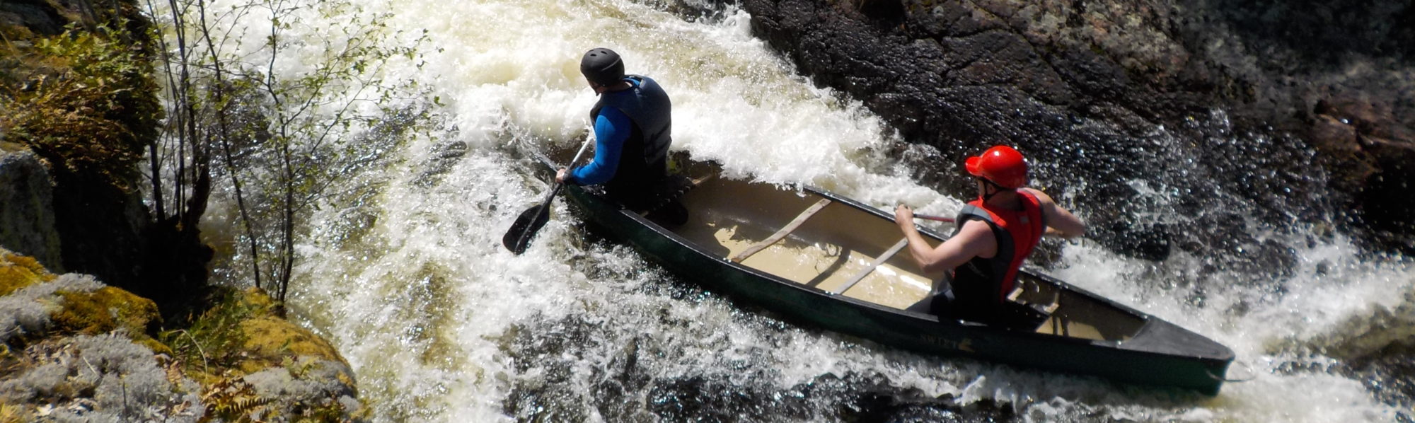
The Hydro people prefer if portagers use the left side of the river to access the Middle Mad, first and foremost because it keeps you off their property, and secondly cause there is a road and it is safer. We decided to portage river right, but not before walking across the dam to check things out. Needless to say when the workers finally saw us, they politely informed us of their displeasure, but at that point we were already loading our boats at the base of the dam so they let it go. To be fair, the torrent of water feeding the Middle Madawaska is an impressive sight. The concerns of the Hydro workers are duly noted, for as soon as we eddied out to begin our final descent, the power and speed of the river was noticeable immediately and was a clear departure from the shallow waters of the Upper Mad.

Madawaska River White Water Canoe Trip – Day 4 – Lower Madawaska River, Swift – R1
The next 1.5 km move through a series of R1s and swifts called the Siberian Ripples. We were able to have a look at these rapids by approaching slowly and having the bow and stern stand up in the canoe and give a quick glance assessment. In all cases it was a matter of finding the central tongue, avoiding any potential pillow rocks and excessive standing waves, and simply keeping line and balance.
Shortly after the Ripples the river gives way to its first major set, the Staircase Rapids. This is aptly named for the rapid is a series of cascading ledges riddled with big chutes, rocks and multiple lines that can be run. A group that went ahead of us took an extreme river right approach that hugged a straight line down the shore. The line required a few manoeuvres to avoid pillows, but as long as the paddlers stayed on their line and did not get drawn into the middle of the set, it was a fairly smooth ride. Funnily enough as we were discussing this, the Mad General and Andre, having decided that scouting the first third of the rapid was all they needed to know, without warning or fanfare simply got in their boats, paddled to the centre of the river, and went balls out straight down the middle. They almost made it. With each successive ledge and thud they took on more water until at last, in the outwash, they attempted to eddy out, but sank. Andre grabbed the canoe, The Mad General the food barrel, and together they were swept an additional half a kilometer downstream into the waiting arms of the Chalet Rapids. When we saw them next approximately 30 minutes later, Andre was still bailing the boat out while the Mad General had one arm lovingly stabilizing the boat, while the other was assisting in his rehydration.

Happy and Johann ran the Staircase next and borrowed from a few playbooks. They took a central left approach hitting the main V as did Andre and the Mad General, but eddied out on the left. From here they dropped down behind the second ledge before eddying out and taking the bottom third of the river through the main channel river right following the path of standing waves. Prometheus and Ahnold took the same approach, but after eddying out, tried to front ferry even further across the river below the second ledge in an attempt to hit the river right V at a higher angle and thereby cut through the standing waves without taking too much water. The line was good, but for both boats the water was bigger than it looked and both boats required bailing after the run.
The Chalet Rapid is a very technical set and sits on the doorstep of MKC. As a result the set is over populated with solo canoes, kayakers and tandem paddlers. It is a teaching set so slalom gates also dot the river and as a result the etiquette of the river changes. In most cases groups will amass at the top of the set, discuss, and then pick an order to descend. This was not the case with Chalet Rapid. Paddlers move freely from shore to shore, often entering and exiting the set a random points depending on the slalom gates they are trying to attack. Also, many paddlers hang out behind eddies in the river, or move up the river despite who is coming down. While we played around a bit with the technical aspects of the set, ferrying and eddying here and there, it became clear that as trippers on a trip and in large fully loaded boats, we should just move on.
The final two sets on the Middle Madawaska are Gravel Pit and Cottage Rapid. We took lunch just before this final offering eating the last of our sandwich meats and cheese, as well as the remaining fruit and GORP. The River Road is all but adjacent to the river at this point so in no time we met a small family on their way to the MKC as well as an older gentleman who needed our help getting his car out of a ditch. He had apparently taken the corner too hard and skidded out. We noted that he was wearing a helmut, but at that point in the voyage little could distract us from the mission at hand
Gravel Pit Rapid has a large hole to be avoided river right, but other than that it was fairly straightforward as long as you kept an eye out for obvious rocks as you turned left around the bend. Shortly after this we came across Cottage Rapid, which was more of a gentle swift, bidding us farewell to the Middle Mad as we were jettisoned into Mud Bay.
Mud Bay is riddled with boats, rafts and various canoes and kayaks. All eco-tourism groups coming off the Middle Madawaska use Mud Bay as the pick up spot. We simply followed a large rafting group the 500 meters across the bay to a towering set of stairs constructed into the side of the hill with 2 by 4s and knew this was our exit.
What a ride.