Wahwashkesh Lake (Bennetts Bay) to Britt
Total Distance 44km

Participants*: Ahnold, The Mad General, Big Daddy Marchand, Captain Kolla, Jesus and Ottawa
*The pictures and monikers below may even bear a resemblance to people you know – your eyes deceive you. These are not the people you know.
Day 1: Thursday May 17, 2018
Travel Day: Ottawa / Toronto – Britt – Wahwashkesh Lodge
T.S. Eliot concludes his poetic opus Four Quartets with the line “you shall arrive at the place where you began and see it for the first time”. The Four Quartets was Eliot’s attempt to bring closure to the religio-historic-philosophical vision he had imagined throughout his career, one that started on the “shores of the tumid river” in The Hollow Men, passed through the “rivers of oil and tar” of The Waste Land only to finally rest “at the source of the longest river”.
In many respects this was also an end for the river vision we had laid out, but this was not arriving at the place where we began. This was arriving at the place that we had been obliterated. One year ago to the weekend we had crawled out of the soul crushing arms of the tumid Upper Magnetawan River and into the oil soaked grey of Lake Wahwashkesh.
So this is where we began. At the source of what had been our longest river.
Getting to Wahwashkesh is a bit of a process, but thanks to the skills of Big Daddy Marchand and The Mad General and the groundwork they laid weeks in advance, the mechanics of the set up ended up running smoothly. This is how it played out:
- Jesus and Ottawa left Ottawa early on Thursday and completed the marathon trek up the Ottawa River Valley arriving at Wahwashkesh with the wetsuits from the east and one canoe rented from an outfitter in their region.
- The Still Mad General, Captain Kolla and Marchand departed Toronto before noon and stopped to pickup two canoes in Parry Sound before heading to the Lodge.
- Ahnold left Toronto at 3pm and did a straight run to Britt, where he met Jesus and The General, who, after dropping gear and boats, completed their 15th hour of driving by moving back cross land from Wahwashkesh to Britt where all cars met up and were parked for a flat rate of $20/car.
- A pre-arranged taxi from Parry Sound picked Ahnold, Jesus and The General up at 7 p.m. and for $185 carried them from Britt all the way back to Wahwashkesh Lodge.
- It is worth noting that while all this happened Ottawa, Kolla and Marchand had 2-3 hours of stress free drinking at the Lodge – and by Lodge we mean a private 3 bedroom cabin complete with fireplace and BBQ not pissing distance from the water’s edge providing ample space inside and out to pack and prepare gear and canoes. Clutch find by The General.
- It is also worth noting that the cab driver told Ahnold to watch out for aliens over the Magnetawan River skies. Given our remote nature there was a good chance we would have a chance for if not direct contact, at least a sighting.
- Nota Bene: despite the fact that half of your team gets to sit around on the shores of the Mag and get putrid, we highly recommend half of you making this effort on the first day. Being able to exit the Magnetawan River on the final day with transportation ready to go minus any additional shuttles is a significant mental break.
Day 2: Friday May 18, 2018
13 km: Wahwashkesh Lake – Andy Vuman Memorial Dam – Beginning of Trout Lake
Considering the sheer volume of satay chicken wings and beer we consumed the night before, our departure time from the Lodge was actually decent. The proximity to the water from our cabin (100m) plus the landing docks made the packing of the canoes a relatively straightforward affair. Once again the beast of burden was the canvas bag devoted entirely to Stiegl and Radlers. Our email communication on this trip wasn’t up to our usual crisp standards so the whole thread about investing more in hard liquor and less in beer was lost in translation.
It is approximately 8 km from Wahwashkesh Lodge to the Andy Vuman Memorial Dam which marks the narrowing of the mouth the Lower Magnetawan River. Wahwashkesh is a deceptively large lake that is riddled with islands and deep bays. It is advised to avoid the temptation to head north out of the bay and make for the farthest shore before cutting west to the mouth of the river. Wahwashkesh is deceptively choppy and the currents of the two rivers colliding in this lake, coupled with any sort of cross wind, make this potential route unnecessarily difficult. We had emerging blue skies and a light breeze, and even these mildest of conditions created some significant rolling waves in the open water. Also, if you hug the shoreline you will lose significant time as there are many a deep and dead end bay carved into the sides of the lake. It is therefore recommended that you first paddle up the left shore of the bay for 1 km, and once you reach the body proper of the lake move from point to point across the expanding horizon, Complete the last 2-3km of the lake by weaving your way under the islands that dot the western bays until you can target the gatekeeper to the mouth of the Lower Magnetawan River – Sandy Hook Island. Sandy Hook Island is distinct not only in name, unfortunately, but also because on its western face its title has been painted diagonally on the rocks. The water level of the Mag can be measured according to how much of the name is visible. We were travelling in high water therefore all we could see was the “Y” break the surface and the “Hook” rising towards the pines. Keep this in mind for the rest of the report as it is the benchmark for the height of the river and the nature of her flow.
As soon as you pass Sandy Hook get eyes and ears up. The river moves at a deceptively fast pace and it is wise to mark your speed against the shoreline. We glided along the Mag’s glassy surface and the 2 km to the Dam disappeared under the easy rhythm of our paddles, hearing the roar of the water before marking her whitecaps dancing across the blue green horizon. The Dam itself is a linear barrier of rounded concrete resting just below the surface spanning shore to shore in an even line. The walls of the river are narrow and pitch, similar to the Upper Magnetawan River, so lining is not an option as there is not break in the consistency and power of the waves cresting the Dam. The portage is river right and is a short (200m) but treacherously narrow goat path that is best negotiated single file. The last section requires you to drop 5 feet through a narrow gap on to a rocky harbor that forms a modest pool of calm to load your boats before shooting the section below the Dam. We placed two people on the rocks below the gap and had the other four people convoy the gear hand over hand. This saved ankles, and more importantly prevented us from jettisoning each other blindly into the river below.
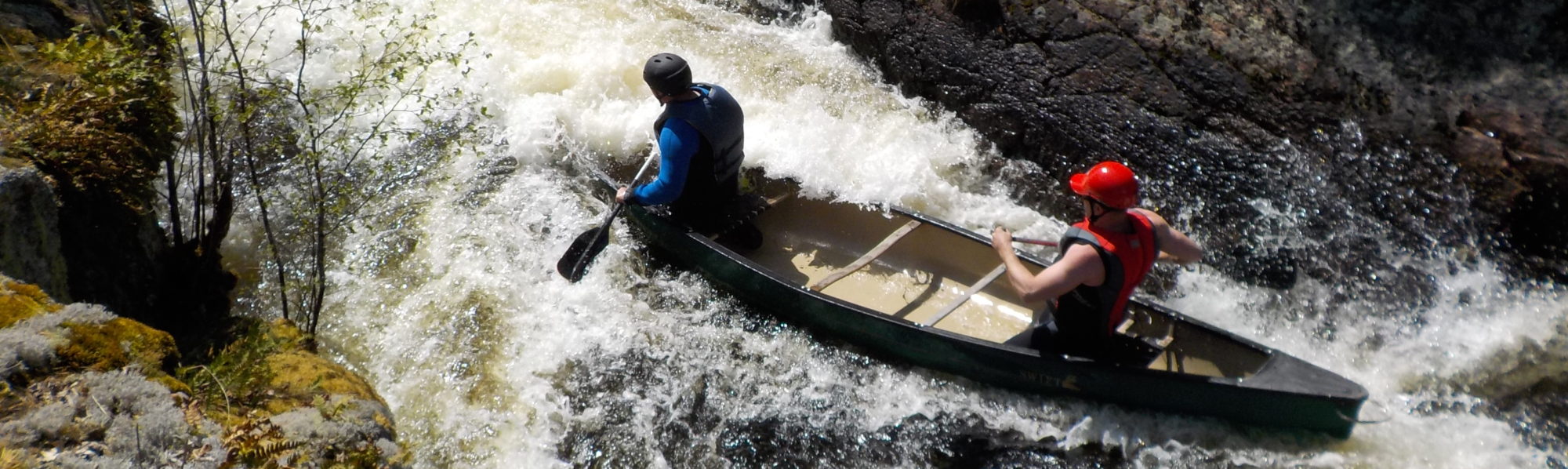
From river right we shot the outwash of the dam which in and of itself was quite powerful and required scouting due to multiple pillows and 6-8 foot standing waves. Jesus and Ottawa ran a very clean route eddying out into a C-curve before dancing across the top of the standing waves river right. Captain and The Mad General had an equally successful run, however Big Daddy and Ahnold, the “two tons of fun” boat, took main street and had to peel out river left only surviving without getting swamped due to their splash covers. Confidence builder all around.
From this point on it is very important to either run the lead boat ahead of the group or to communicate the topographic indicators that signal the next set in the river. Pay close attention to the streams and creeks that flow into the Mag and use them as a measurement for your speed. The river moves fast, and the kilometers can evaporate quickly, especially under the siren song of the ever changing landscape of shield rock, pine beds and warm sun shimmering through the towering trees. A group lost in conversation can easily find themselves being drawn into the gathering quick of an unmarked set of white water and scrambling to make land before being drawn down. Case in point of this is the next set barely 1 km below the Dam which is unmarked on the map, yet is easily an R3, and for the purposes of this report will be named Honky Lobster[1].
Honky Lobster is shaped by two large islands (Honky & Lobster) that present themselves in the middle of the river stacked one on top of each other. The first island, Honky, splits the top of the set and is the perfect vantage point to scout, so aim dead centre of the river and speed burst onto the exposed rock. We were not in a position to take advantage of it, but Honky is a fantastic place to camp, complete with padded down tent zones, a clear fire pit, ample wood and a sheltered breeze from the bugs. River right is a straight 500 meter run of ledges, holes, massive standing waves and pillows. We took a long hard look at this section but determined that with fully loaded boats the required sequence of eddy-outs, c-curves and s-curves necessary to zig-zag through the set would be too much for our meat & beer bloated boats to handle and the risk of getting split and tumbled with little river rescue support was too great. Although the river opened up into a mini basin below this set, it was a long, jagged staircase of hurt to the bottom. It is also worth noting that due to the high water the right shoreline was impassable, so the option of lining or even setting up rescue personnel on the opposite shore was also not available. In lower water this may not be the case and a route could open up. The left side of Honky became the settled route, but also presented some challenges. The top half broke in a slow curve pumping the water between the island and the steep main shore in a mini funnel. The outwash pushes you in two equally difficult directions towards Lobster, the second island. The top route would take you over Lobster and inject you into the middle of the long river right set mentioned above, and the left course set you over a 10 foot waterfall hidden on the underbelly of Lobster. We were discovering that along the Lower Magnetawan River many of the sets were born of a fracturous drop in the Canadian Shield. Objectively, it is stunning to stand in the middle of remote Northern Ontario and gaze long down the winding river to see the point in the horizon where the trees drop uniformly by degrees into the falling pitch. Up close, it is even more breathtaking to feel as though you can straddle the Canadian Shield at the exact place it heaved and sank, dragging rock and tree into the water below. Subjectively you wonder how the fuck you are going to get through this mini gorge in decent time without being annihilated.
The plan became to shoot the top curve down the centre riding the large standing waves and eddying out either right or left, whatever became the easier route. From there we would power across the mid section and aim for the middle of Lobster. The high water offered a shallow gulley of water that had worn down a ridge of rock. Collectively we could lift our boats over the spine of Lobster, and then shoot the last quarter of the set centre left below the last major ledge. Once again Jesus, Ottawa, The Mad General and Captain Kolla had very clean runs through the mini gorge and made Lobster with minimal anxiety. Big Daddy and Ahnold plowed their way river left after deciding to hit every standing wave in the gorge, then powered across to Lobster where they dry heaved. The good news is that all three boats were lifted over into the main channel incident free and Big Daddy and Ahnold got some of their mojo back by shooting the bottom quarter of Honky Lobster clean.
As with the Upper Magnetawan River, the only way I can describe the major portages on this river is through the lens of Lord of the Rings. There is a scene in the first book when the fellowship is paddling down the Anduin and they come to the Argonath, which are two massive pillars of stone out of which the kings of old are carved. These pillars stand vertical and proud marking the entrance to a narrow, sheer walled corridor of water and rock that serves as a gateway between sections of the river (and the border to Gondor!). Canal Rapids (and Thirty Dollar who we will meet later, and the Widow Maker from last year) all share this presence. Less than 1 km below Honky Lobster the bones of the river rise up in vertical pillars marking the entrance to Canal Rapids. The portage, if you can call it that, is river left and is marked by be a series of desolate pink ribbons wrapped strangely around a series of trees near the water’s edge. The portage is a two part masterpiece of pain spanning approximately 1 km in length, but rising at least half that in elevation. The first 20-30 meters is a steep dirt track through the older forest to an open grassy plain marked by a monolithic rock that has no business being there. You almost expect the apes from “2001: A Space Odyssey” to leap out with boneclubs it’s that out of place. Follow the open grass across the top of the Rapids (20 meters) to the forest and then prepare for an aggressive push of an additional 20-30 meters through a very dense segment of thin trees and marshy streams. It is advised that those carrying canoes travel with a partner since this final section is very difficult to negotiate given the limited space and angle of the boats. To whatever extent you can, move in as straight a line as possible parallel to the river and at 90 degrees from the clearing, and you will come to an ATV road. Once you hit this road follow it right down to the river (20 meters). It will take you to an established clearing at the edge of a bridge. From here the put-in is obvious.
Although late afternoon was setting in, we decided not to camp at the outwash of Canal Rapids. The site, though broad, well established and flat, was disgusting. It was clear that ATV users treated this as a garbage hub. A dilapidated outhouse had become a storage box for burnt beer cans and old posters, and oil and gas stains could be seen throughout the clearing. We loaded our boats below the bridge on a rock garden and pushed forward to Grave Rapids, which was some 200 meters around the left curve of the river, and either hoped for a runnable set or a good campsite. Or both.
In an irony only becoming of the Magnetawan, Graves Rapids, the ‘marked’ and ‘named’ set on our map (aside from Canal Rapids which is not a set but a test), was nothing more than an R1 that provided, and I quote from my notes, a “centre left bouncing surf ride” into the last ribbon of narrow water before Trout Lake. At this point we decided to make camp having met our target distance for the day, and despite the river opening up into a broader body of water, it took several kilometers for the hard edges of the river to give way to suitable camping ground. It is only fair to point out that prior to this section of the river, and at almost every point from Sandy Hook to Canal, there were campsites a plenty. This sudden stretch of limited options was quite the surprise. After some searching and a bit of anxiety, Captain Kolla, Jesus and The Mad General found a magnificent outcropping of elevated shield facing due west right at the point that the Lower Mag opened up into Trout Lake proper.
Jesus and Ahnold built a cairn and pyre from loose rocks, Ottawa got dessert ready before dinner, Captain Kolla put on more sunscreen, Marchand read the original script for his podcast “Camping with Big Daddy” and we ate The General’s sausages over a little stick fire, enjoyed a pure blue sky give way to a pure distant sunset drinking Stiegl on the gleaming edges of the rock bones of our country.
Day 3: Saturday May, 19, 2018
13 km: Trout Lake – Mountain Chute – Stovepipe Rapids – Island Lake – Three Saye Rapids
We got a little bit lucky and a lot wet today. The little bit lucky came from the fact that we had broken camp after a delicious breakfast when the rain started the moment our paddles touched the water. The lot wet was due to the fact that what was supposed to be 1-3 mm of rain turned out to be bullshit. A slow drizzle with very little wind guided us up the remaining 3 km of Trout Lake and into a fascinating transitional point. The lake opens up river left into a deep bay, and given the sudden expanse, the temptation is to move with the main flow of the water into this basin. A large island presents itself immediately and once again the temptation is to go under the island since the main channel appears to be bellyside. All paths in this direction lead to dead ends. Instead, take the north side of the island and follow the narrow channel to the first break in the land river right. It will appear as a marshy switchback and the narrowness of the ribbon of water cutting north intuits that this is the wrong way – that you are moving away from the major water instead of towards it. You are not. Stay in these curving narrows until you hit the equivalent of a t-junction for water. Once again you will intuit that you should go right, towards the expanding water, but this is a false flag and unless you want to hump it through 1.5 km of marsh and enjoy all that Duck Lake has to offer, don’t do it. To your left there is a small gap in the trees and a gentle swift where the river pinches, and beyond, the continuation of the Lower Mag. We navigated this transitional moment under slow mist and heavy air, so the whole process, from the swollen river to the sunken reed banks of the land felt surreal. We even passed a soaked fisherman with his dog moving slothlike in silence in their tin boat adding a deeper dimension to this looking glass threshold.
The next 4 km are a straightforward paddle towards Mountain Chutes and very much the antithesis of the daydream souvenir disappearing in the rain behind us. Stay river right and hold to the north shore since the southern side in cratered with multiple bays and tempting creeks that are all dead ends. The river is wide, but her pace is strong, so pay attention to the geographic markers and the gentle narrowing of the land as you move forward.
The portage for Mountain Chutes is river right and there are several obvious pull out points depending on the water levels. We took the first, most conservative exit due to the pull of the water towards the chutes, but there was a second exit 50 meters below that puts you closer to both the base of the hill you have to portage, but also closer to the mouth of the machine. The portage is a beast and in wet weather even more delicious. It is only about 600m, but the first 200m is a narrow single file path up a slick wet rock and loose dirt track. There is a good campsite here, but the falling rain and sweat, and the desire not to break our ankles took away from appreciating the scenic nature of the moment. Once you crest the hill it is a gentle 400m descent to another established campsite and put-in. The rain actually became an ally on the back 400m as the downside of the ridge was covered with soft, damp grass. Those who had suffered the incline with canoes on their backs were able to put the boats down on this slick turf and easily pull the boats almost to the end of the portage. At this point the wet was seeping in, and any significant pause in our pace ran the risk of causing a chill. We powered up on some super snacks (thank you Jesus, Ottawa, General or Daddy – I can’t remember whose bag of goodies carried us through this threshold, but I know that all of you either had power bars, GORP, chocolate or prosciutto at the ready), loaded our boats, and punched the 1.5 km across the wide bay on the way to Stovepipe Rapids which sat at the next narrowing of the river.
Stovepipe was a solid R2 in big water but a lot of fun. With minimal scouting we ran it on a straight line taking both major tongues right down the middle. The only caution was making sure our lines for cutting the large standing waves were either surgically dead on, or in some cases skirting the whitecaps in the bottom section just to the right or left. Captain Kolla, The Mad General, Ahnold and Big Daddy had splash covers so they took the former option. Ottawa and Jesus, who did not have splash covers, performed the latter.
At this point we got a small break from the rain, but the grey low hanging skies made it clear that we were far from done. The final 2km of this section of the Mag is a straight run to Island Lake. The river is wide and swollen, and the only obstacle is a dead end bay river right that you would really have to work to get lost in. Island Lake is relatively large, considering it sits in between two segments of a Northern Ontario river. The way forward is on a diagonal line of 500 meters towards the series of islands that obstruct your view of the Mag’s continuation. There is the possibility of missing the mouth of this next section of the river by aiming too low and following the clearer path of the lake, but if you aim south west for the largest visible island as soon as you crest the point of the outwash of the previous segment of river you can’t go wrong.
Island Lake exits back into the Mag along two paths. River right appears clear on most topographic maps and satellites, but when we arrived it was clogged with debris. The left channel, which appears more narrow on maps, was actually a small swift that gave us a nice little burst of momentum going into the last 2 km of uneventful river paddling upstream from Three Saye Rapids.
Three Saye is a jagged ridge that rips diagonal across the river in three pronounced claws of rock and water into a series of thundering cauldrons. The portage is river left and fortunately very clear and very pronounced. It is a short 500 meters that opens up into a magnificent campsite perched above the outwash of the rapids, but with a perfect angular view of all three waterfalls. This campsite has established benches, cooking and cutting platforms planked between three trees, and when we arrived soaked and muddy there was a small cache of precut wood. The rain fell a bit lighter, giving Big Daddy just enough time to establish his second podcast called: “How to Set Up a Series of Tarps in a Windstorm to Keep Your Team Dry while also Building a Promethean Fire to Keep your Team Warm.” Honestly, what the man did this day was incredible. Captain Kolla applied more sunscreen, The Mad General established wifi, Jesus and Ottawa cooked a gourmet meal of ingredients I can’t even begin to describe, but the preparation, packaging and ultimate presentation of the meal was exactly what we needed on this wet day, and Ahnold took notes.
The long day waned.
The rain continued.
Wet bones in a sunken land.
We all play our part.
Day 4: Sunday May 20, 2018
4km: Train Tracks – Thirty Dollar Rapids
The rain stopped sometime in the night preventing the campsite from becoming a mud swamp and affording us dry clothes to start the day. We had a Spartan breakfast of coffee and granola, and maybe some more meat. I can’t be sure as it all starts to blend together. And drinking in the rain from the night before clouded my memory. But the important thing is we were fed and in relatively little pain.
1 km below Three Saye there is an unnamed set that appears as a single line across the river on the topos. In low water this may be a navigable R2 with some lining options, but for us, unfortunately, the main channel was cut with a significant ledge that created an impassable hole. River right offers a short and very well established portage trail of 50 meters maximum that is an easy flat haul.
Yet another kilometre downriver the Mag is cut by the Canadian National Railway. This set does not appear on the topographic maps at all but was magnificent. Just before the bridge you can exit river left to any number of the rock outcroppings available. Follow the boulders on the shoreline to the moorings of the bridge and then use the concrete slabs to walk right under the tracks and scout the top section of the rapid. Just below the bridge the path continues and the second half of the rapid can be viewed from a series of protruding rounded spoons of shield and grassy patches that make for a brilliant campsite. The next time I do the Mag I am aiming for this spot as an overnight. It is the perfect place to rest, practice, and fuel up before all hell breaks loose with what comes next. The top of the set itself is a wild rollercoaster of tongues and curling waves generated from the river converging under the tracks. Below this initial drop two large tongues, the first river centre and the second centre right, greet you with 3 haystack standing waves each. It is essential to set up your line correctly on this approach or else, as some of us found out, the rest of the set will be experienced from the neck up. One their first run The Mad General and Captain Kolla, valiantly, extended a bit too far river right and were corkscrewed by the standing waves waiting below. On their second run, they moved more centre left and caught a line that allowed them to bounce through the top section with enough gunwale room to push river right and ride the two main tongues above board. Jesus and Ahnold tackled the top section dead centre, and despite going ‘sky – water – sky – water – sky’ landed with enough balance and power to ride out the bottom two tongues easily.
And then.
In the words of the great Aussie Rules Footy Coach whose name I don’t know: “today…today was not the day the teddy bears had their picnic.”
Thirty Dollar Rapids is a 1.5 – 2 km piece of savagery that consists of 4 towering chutes of whitewater that becoming increasingly wedged between the sheer walls of a narrow canyon. The first set is the vanguard of this behemoth and rests upstream in the opening mouth of the canyon. It is just far enough removed from the other 3 sets that you can exit river right and portage over the flat table top of rock that frames the first drop and put back in thus saving some of your strength for what is still to come. To be fair, in low water, an argument can be made for attempting the same approach to the second chute. The water was calm enough after the first drop for us to power across the river to the left bank where the portage proper started, therefore to shuttle down to the next exposed rock ledge and potentially perform the same task is very conceivable. Hell, in really low water you might be able to make it all the way down this way. That being said…
What follows next is what not to do on a portage, although, from a negative comes a positive, and in this respect we learned in the most unproductive and soul crushing way how best to tackle this beast.
What not to do:
- Do not separate as a group and become strung out along the left shore. There is no clear path and the topography will drive you ever increasingly away from the edge of the river / cliff and into isolation.
- Do not attempt to paddle to the second ledge, portage it, and then shoot the bottom half of the river in big water. There is no capacity for river rescue and if you go into the drink you need to be able to swim out of the canyon with your boat and all your gear.
- Do not attempt to line Thirty Dollar Rapids as even the most benign eddies and enclaves along the edge of the river are slick and powerful. Either you or your boat will be swept away, or you will end up climbing out of the canyon with a boat on your back.
What to do:
- At the start of the portage there are a series of pink ribbons. Read them.
- If the ribbons are no longer there at the water’s edge look for them in the trees at regular intervals rising up at the edge of the tree line.
- Follow these ribbons even though they appear to be taking you south (left) and well away from the river.
- There is a well established ATV trail that sits hidden some 100 meters south of river (very left) beyond a slow rise of pine trees and across a sunken plain of moss and water.
- Once you find this trail, mark this access point with a bag, or bandana, or something, and turn right.
- Follow this path religiously. It will lead you down to a narrow crossing where a small stream flows into a magical valley populated with bluebells and fiddlesticks before rising up one last time into the woods and then down again to fallen boulders and fragments of Shield, and more importantly open water that signals the end of purgatory.
- Retrace your steps along the ATV path to your marker.
- Cut north (left to the river) to the pink ribbons and your gear.
- Repeat.
*An aside and only discovered after one hell of a day:
Just before the canyon drives to its magnificent conclusion there is a sudden open glade no more than 50 meters wide where the stream I mentioned earlier along the ATV trail empties into a flat basin that leads to the river. This wedge of lush green and brown is framed on both sides by ragged, aggressive vertical rock that is almost impassable. In the midst of this torrent of noise and splinter and edge, this small valley sits as much a contrast in tone as it is in colour to all that surrounds it. The exit to the canyon is in fact the western rising wall of stacked rock, and as evening approaches the fading light of the setting sun will turn the inside face of the final pillars of Thirty Dollar to burnt orange and the tops of the waves whiteblue, and this little valley may, for a brief moment, be one of the most perfect places on earth.
The Magnetawan is a hard river, but what she offers in return – and at a cost, is something very few have touched.
And so the last of the earth left to discover is what was there from the beginning.
Good Luck.
OR:
You may dance to the tune of The Mad General and shoot any rapids that do not appear to be obviously lethal. Before setting off he expressed that he and his ilk weren’t made to carry boats, and that he didn’t come here to stay dry. Off he went, with Captain Kolla in the bow. Dry they were not, and carried by the waves they were, on the wrong side of the hull.
This too is not the way.
Our day ended with The Mad General floating through the gates of Thirty Dollar Rapids and across the subsequent bay to a western facing hill of bald rock whereby he established camp with nothing more than his canoe and paddle, wondering what was taking the rest of us so long. Captain Kolla soon joined him thanks to a shuttle from Ottawa and Jesus and added some additional personal and collective gear to the colonial outpost. Jesus and Ottawa then went and found Ahnold and Marchand in the canyon and helped belay them up the rock wall. By sunset all four remaining members of the group had managed to make it across the bay where The Mad General was still not quite ball dry. Big Daddy broke out the chili and completed his third podcast called: “How to Resurrect Your Team After They Have Suffered at the Hands of Shitty Leadership” while Captain Kolla somehow managed to find the energy to secure the campsite by doing the dishes, packing up the food and securing clean water. Someone demanded more meat tapas, but that delicacy was going to have to wait.
Day 5: Monday May 21, 2018
12km: Miner Lake – 3 Sets on the Magnetawan Nation – Highway 69 Revisited – Britt
The last day on the river is always a strange mixture of nostalgia and pressure. On the one hand, you plan for a quick exit in advance of all the logistical time that will be required once off the river, yet it is also hard to let go of the journey, especially when you know that if worst came to worst you could eat a Big Mac at midnight in Parry Sound.
With that in mind we made quick work of breaking camp off bald rock and covered the 2 km of Miner Lake to the edge of the Magnetawan Nation in very good time. Upon entering the Magnetawan Nation Land the river starts its final approach to Britt and begins to narrow over the next 3.5 km before erupting in the first of three monster sets. For some inexplicable reason these sets are marked on the topographic maps, but unnamed, which is baffling considering how powerful they are. The first set looks as though two Druidic stones were slammed across the river thus forming two massive ledges that are impassable. The portage is river left and a rough hewn path will lead you across a rising ridge away from the river. This portage, given the steep nature of the edge of the river, runs the risk of becoming more work than necessary, so it is advised, as we did, to scout for the first rock bay below the second major hole and employing the convoy system of Mountain Chutes, drop and load your boats one by one so you can get on with your day instead of walking an additional 100 meters downstream. In high water the outwash of the first set was significant, therefore a small swift was created by the river pushing around the island located just downstream. This may not be the case in lower water. None the less, as soon as you clear the island get river right as the second set is almost immediate and aim for the raised hill with the lone tree that has a boat chained to it. This is the start of a very brief 300 meter portage that will deposit you below the main ledge the juts out from the right shoreline and forms the major obstacle for this set.
It is necessary at this point to take the proper time to acknowledge what happened next. The Mad General, quick to understand the math, made the decision to run this set solo. In a suicidal wedge between the bow seat and the splash cover, he took the long extended tongue that curved river left and braving the sea of standing waves and mad curlers, maintained balance and poise and rode through unscathed. It was essential that his line at the top cut the tongue at a surgical 90 degree angle, and in the middle and bottom sections his back paddle dip firm and steady. The result was the best run of his life.
And then…
The exit border of the Magnetawan Nation is marked by a third and final set created by an outcropping of sharpened rock in the middle of the river that looks like the silhouette of an Imperial Star Destroyer. The portage is river left and is an established single file goat trail complete with winter battered fishing blinds that hugs the steep shoreline. It is only 400m but its technical requirements are exactly what you would expect from the Magnetawan who is refusing to give up her dead. Once again The Mad General decided to run this set solo and opted for the pumping water on the left side of the river closest to the portage as his line. Once again this was a tremendous feat, one that can only be understood as follows: His first run was Ridley’s Scott’s 1978 Alien – a thing of beauty unto itself. His second run was 1986’s Aliens – perhaps the only example in modern cinema where the sequel was better than the original.
The final 2 km of the river lead you under Highway 69, the final sentinel on this magnificent journey. One last set – an R1 that can be shot right, centre, right and left, taking the tongues all the way and staying in the dark water, does warrant a quick look given it breaks upon you from around a blind corner and lies under the shadow of the bridge. It is fitting that the Magnetawan should test you right to the end. Just note the exposed rocks and visible white caps. Avoid both and you are fine. After that, the dilapidated docks of Britt welcome you home.
We exited the Mag with a sense of relief and accomplishment. Something that had taken two years, 8 different combinations of paddlers, 3 different outfitters, 2 cabs, 1 hitchhiked ride, 1 broken boat, and countless logistical hours had finally come to an end. I had stood on top of the Highway 69 Bridge three years ago and imagined the effort and skill that it would take to experience this great Northern Ontario river; what would be required to pass beneath this bridge. The Mighty Mag did not disappoint. It was ruthless and rugged, merciless and magnificent, and in the end, one hell of a mental and physical test.
And so, I suppose after all that, we do “arrive at the place where [we] began and see it for the first time”.
[1] This term and all subsequent references are the trademark of Captain Kolla LLP, the original Honky Lobster
Pingback: Upper Magnetawan River Canoe Trip Report, May 18-22, 2017 - For Whom The River Rolls