Petawawa River Canoe Trip
Lake Travers – Petawawa River – Lake McManus – approximately 50 km
May 15-19, 2014
In attendance: Arnold, The Mad General, Sam, and Jesus
For Baby Scheinstone.
Someday, this will all make sense.
Thursday, May 15
Toronto – Pembroke
The Mad General and I escaped from Toronto at dusk and headed east through light 401 traffic towards Napanee and the great wilderness beyond to begin The Petawawa River Canoe Trip. The trip was uneventful save for our usual stop at the 7th circle of hell otherwise known as Kaladar, where the 41 crosses the 7 before launching into the lake-district just south of Algonquin.
We had booked a hostel just outside the Park Gates and after almost careening off the highway just past midnight and clipping a few orange pylons, we found Jesus and Sam soundly asleep in one of the two rented rooms. They had made the arduous trip from Ottawa sometime in the afternoon, and while the Mad General and I had spent the last 5 hours getting the poison out, these two had clearly had themselves a nice little pre-party. They did leave each of us a beer and half a salami, so we decided not to be too obnoxious and just went to bed.
Friday, May 16
Lake Travers to Big Thompson Rapid 10 km
We awoke relatively early and began sorting our gear. The hostel was a top rate operation that provided the majority of the equipment and logistical support, as well as sage insight into the Mad General’s psyche. We had one more stop at the edge of the gate to collect a few additional supplies where Sam shared with not only us, but the owner as well, his humble start as the son of a carpet weaver.
We made the put in at Lake Travers off Achray Road just before noon. The road takes you right to the southern edge of the lake just below the outwash of the Polar Rapids / Dam that constitutes the end of the Upper Petawawa. A grey sky that threatened rain, and for a moment it seemed that the 5 km maiden voyage would take place under challenging circumstances. The crossing was a good shock to the system and Travers provides enough width and water that in high winds the 5 km could be a push. Fortunately the rain held off, as did the wind, and we were able to make good time and pace.
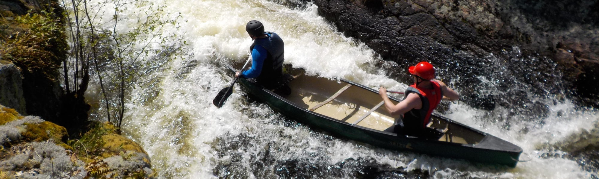
Although the map indicates that Big Thompson Rapid is 5 km from where Travers ends, it is strongly advised that as soon as you see the river narrow after the series of islands that bridge her northern mouth, you move river right and listen for the rapids. We heard Big Thompson before we saw it, and in high water, which this was, the size, speed and potency of the rapid was akin to some of the heavier sets seen on the Coppermine in the North.
We exited river right and followed the clearly marked portage trail to an open campsite nestled 1/3 of the way down the rapid. The site was half way between the portage trail and the exposed, magnificent boulders of the shield that framed the edge of the river. From the rocks we could scout the majority of Big Thompson and position ourselves as safety nets for each run of the set.
It is important to note that every attempt we made at Big Thompson was an effort in futility and survival. Even in empty boats the water was thunderous and savage. On our first attempt the Mad General and I learned how to fly when a corkscrewing standing wave launched us from the boat. Jesus and Sam fared better, surviving the top of the rapids’ massive standing waves, eddying out river left, before attempting a front ferry to river right for a second eddy out. On the latter ferry they swamped due to the size of the water. The Mad General and I made another attempt, and though this time we survived the standing waves at the top by bracing low and eddying out hard to the left, when we attempted to eddy out and complete the set we ran full tilt into a standing wave whose impact was that of a freight train thus sinking us where we sat. The Mad General attempted to perform some basic thermodynamic calculations as we sank, but it didn’t help. Apparently the river doesn’t read textbooks.
All joking aside it is important to note that when the Petawawa is running as hard and fast as this, if you bail in the Big Thompson you have a very small window to get yourself and the canoe out of the rapids. Little Thompson sits but half a kilometer downstream and should you lose your canoe, paddle, pack or self, you have about 1-2 minutes in the river to get organized, or else everything will be swept over a second intense rapid and you will be looking at being washed out 3 km away.
Feeling thoroughly defeated, we sat down for a feast of sausage and steak. The rain set in light and damp just after dark, so between that, the beating we took from the river and the fact that someone lost the Steigl*, we called it a night.
*In the words of fellow fishermen we met further down the river, the loss of the Stiegl, which, in point of fact was a flat – 24 king cans of the finest biere, still encased in shrink wrap placed to cool in a seemingly calm eddy of water midway through the afore described raging Big Thompson Rapids – was an offense that ranked one step below vehicular homicide and one step above marrying your cousin. The shame of his error, and that individual who must carry the mark of Cain upon him, shall not be soon forgotten…
Saturday May 17
Big Thompson – Little Thompson – Grillade – Crooked Chute – Rollway Rapid – 12 km
The damp weather passed in the night and we awoke to a crisp morning and clear skies. After a hearty breakfast we portaged the boats to the outwash of Big Thompson, put on our wetsuits, and shuttled some 400 meters or so across the river to the left side to scout the clearly marked portage trail for Little Thompson Rapids.
Little Thompson was very runnable in high water, but the weight of a full boat needs to be considered if taking the main channel. The heart of the rapid flows through a central tongue that pushes left around a ledge before driving the river up against a massive slab of exposed rock. Taking this route will require a tight line around the ledge and the ability to eddy out hard to the right to avoid colliding with the rock wall. The Mad General and Sam tried this route but took on too much water trying to curl out of the main channel and swamped. Jesus and I opted for the more conservative approach and front ferried across to river right before taking a rocky but fast moving straight line down the right shore. Once we collected the boys in the outwash and performed a little canoe over canoe rescue, we were on our way.
The next 5 km of the river was a rapid eastward descent towards Grillade. The river widened out slightly, but kept her pace, and the land opened up a bit into a broader Algonquin vista after being framed by the rock of the Thompson Rapids. Grillade in and of itself is a technical R2 in high water that offers multiple routes for those interested in taking the time to scout different lines across the river. The problem is that Grillade feeds directly into Crooked Chute, which is impossible to run in a canoe. To this point, we ran into a group of weekend warriors at the bottom of the Chute who were renting a cabin close by. Fuelled by vodka and gas fumes they decided to send an empty boat over the falls and with much delight showed us the remaining half of the canoe that they had managed to drag out of the churning whirlpool at the bottom of the set. A good map will show paddlers the 3 distinct options for getting out river right, based on how close to the edge you want to venture, but to be safe it is strongly recommended that you walk the line of the entire set river right so you know exactly where you are aiming to exit. We decided to follow a series of short, technical routes that held tight to the right shoreline and dropped us a couple of hundred meters above the lip of the falls. Although the river at this point is visibly shallower than the Thompsons, it still moves quickly and drives towards the Chute at an unexpected pace. It is imperative to stay tight to the shore and not be afraid to eddy out sooner rather than later, especially if things begin to feel a bit out of control. Both our boats ran a good line, navigating the standing waves, pillow rocks and ledges, but in both cases we had to cut out off the river hard and with no lack of intensity.
The portage around the Chute is far more complicated than it needs to be. On paper, the portage is a couple of hundred meters, but the path you follow is a painful rise and fall of rock steps on a widening arch that eventually drops you in the bay below the falls. The view of Crooked Chute from below is impressive and offers a humbling perspective on the size and power not just of the Petawawa, but also the land that frames her. The bottom of the Chute is a seething cauldron of churning white water held within a large, graceful arch of erosion smoothed cliffs at least 15-20 feet tall. The bay that has been formed is wide and deep, but the power of the water and the conflicting boils and eddies could be felt even as we attempted to break away down the river towards Rollway. Caution is advised until you are firmly back in the narrow part of the river. Case in point, while Jesus and I were partaking of the vodka offered by the cabin dwellers, Sam and the Mad General finished the portage a little later only to see an exhausted canoeist struggling in the middle of the bay, frantically waving for assistance. He had attempted the lower part of the chute and had been summarily consumed by the river. Somehow he managed to swim back to his boat, but it was all he could do given the power of the wash to hold on to the gunnels of his boat and call for help. The boys brought him back to solid land.
Rollway Rapids is less than 2 km from the Chute and similar to Big Thompson in that the set is heard before it is seen in high water. The memorial for the drowned sets the tone for this beast that can only be run in mid to low water in an open canoe. The portage trail follows the right shore and much like Crooked Chute, weaves its way through a series of mud paths, wooded glens before taking you up and down a precarious stone staircase that deposits you just below the rapid. The walk itself is quite beautiful, when you are not in pain, and the return trip gives you a great sense of the varying stages of Rollway in all her power and potential. It’s worth noting that parts of this portage have been described as only being suitable for “mountain goats.”
Although we only travelled 12 km, the intensity of the white water, coupled with the two portages, as well as the fact that we had been wearing wetsuits all day, drove the decision to camp just above the Natch Rapids. Once again we ate like kings courtesy of Jesus and the Mad General, but alas, the river would still not yield Ahnold’s lost Stiegl, so we settled for absinthe instead. Much like the river, but opposite its coldness, the absinthe would wind through your body like a coil of fire, more burning than warming.
Sunday May 18
Natch Rapids – Schooner – Five Mile Rapids – Whitson Lake – 17 km
We awoke to another glorious day of blue skies and calm breezes. After eating our way through another round of bacon and eggs (I think) and 17 coffees we set off to scout the Natch and catch a glimpse of the burnt orange cliffs made famous by the Group of Seven. For us, the Natch was a gorgeous series of winding tongues that move arch to arch in linked semi circles through the pine laden valley of exposed rock. Although we scouted it to be safe, in the end the river really did the work and we were able to take in Tom Thompson’s view of “The Petawawa Gorge” (below) as we rode the main overlapping tongues all the way down.

Tom Thomson, “The Petawawa Gorge”
The river opens up just after the Natch into a beautiful wide bay ringed with red rock cliffs. Jesus and I explored a few options for cliff jumping, and after convincing me to climb up a relatively exposed piece of rock on the south side of the bay, he thought it would be a good idea to incentivize me to actually jump by paddling the canoe into the middle of the river. Not sure exactly how it played out, but somewhere between me swearing at him and trying to throw a stick, I slipped, smashed my cheek off the rock, and dropped 15 feet straight into the river. For good measure, Jesus made me swim to the boat. The Mad General and Sam saw nothing.
For the next 3 kilometers the river slowly thins and the topography does not become as severe. The Gorge really marks the end of the river defined by strong rock outcroppings and thick pine shorelines. From this point on the Petawawa begins to open up as she heads for the Ottawa Valley. The horizon expands and the land flattens out as more hydro lines and bridges take view.
Schooner and Five Mile Rapids can almost be approached as one long 11 km R1 interrupted briefly by Coveo Lake. The river had enough speed and chop to it that it was important to remain kneeling in the boat for the whole set, and even though not much technical manoeuvring is required, it is important to keep your centre of gravity low and be aware of your balance. We ran into what appeared to be a group of vegans being guided down the river by some poor schmuck just trying to get laid just before the final drop to Whitson Lake. Smelling blood, this gave the Mad General the chance to strike a meaningful conversation with the vegans about “river terminology”. He was very proud of himself. Jesus and Sam wanted none of this and promptly smashed the last of the summer sausage and chased it with apples before leaving me to wrestle the Mad General away from his new found friends.
A grey sky settled in as the Petawawa’s last offering of swifts and R1s gave way to the stale waters of Whitlock Lake. In high water the swell of the river bloated the lake to such an extent that most campsites for the 2 km of the 2.5 kilometer wide lake were completely washed out. We had intended to push to the eastern point of Whitlock, but the swollen shores made it a necessity. Unbeknownst to us in advance, just before Whitlock compresses to form a tiny swift that connects to Smith Lake, there is a magnificent sand bluff and on her heights sits a beautiful campsite facing window to the west. We paused at her base to simply organize ourselves, but once Jesus attempted to throw the Mad General into the river, madness broke out and Sam, in an attempt not to have his shirt ripped from his back by the rabid General, fled up the bluff and discovered what turned out to be the most coveted spot on the lake. Once we decompressed and a peace treaty was reached, we settled up on the heights and quietly watched a smattering of envious groups of trailing paddlers float past our perch while the sun set bold and full in a perfect westward descent across the endless Canadian horizon.
Monday May 19
Lake Whitlock – Smith Lake – McManus Lake – 8 km
The Shins said it best in New Slang: Dawn breaks like a bull through the hall and my head`s to the wall and I`m lonely.
We crawled out from our tents and struggled through a morning meal of oatmeal and GORP, evening out the blood with the last of our coffee and darts, before preparing for the final push down to the take out. If the start of a trip is met with joy, the last kilometers on any river adventure, no matter how big or how small, are often met with silence and sadness.
We quietly worked our way up Smith Lake feeling as though the Petawawa lay distant at our backs; her waters hundreds of kilometers behind us, rather than half a day west. Lake Smith became Lake McManus and the dull roar of the Petawawa Military Base let signal the end of our time in Algonquin. The take out was obvious and already humming with activity from the outfitters and the groups we had viewed the night before from our lofty tower of sand.
Jesus and Sam volunteered to take the canoes and rental equipment back to the outfitters allowing the Mad General and I to get a jump on the long road home. Our cars were ready and all that was left was the good-byes, second star on the right and straight on till morn.